


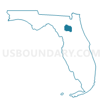
1-County Voting District 1, Alachua County, Florida
About
Outline

Summary
| Unique Area Identifier | 550802 |
| Name | 1-County Voting District 1 |
| County | Alachua County |
| State | Florida |
| Area (square miles) | 38.02 |
| Land Area (square miles) | 36.22 |
| Water Area (square miles) | 1.80 |
| % of Land Area | 95.26 |
| % of Water Area | 4.74 |
| Latitude of the Internal Point | 29.81224930 |
| Longtitude of the Internal Point | -82.29330010 |
Maps


Graphs
Select a template below for downloading or customizing gragh for 1-County Voting District 1, Alachua County, Florida


Neighbors
Neighoring Voting District (by Name) Neighboring Voting District on the Map
- 11-Voting District, Bradford County, FL
- 13B-Voting District, Bradford County, FL
- 15-Voting District, Bradford County, FL
- 324-Gainesville Voting District 24, Alachua County, FL
- 325-Gainesville Voting District 25, Alachua County, FL
- 601-LaCrosse Voting District 1, Alachua County, FL
- 901-Waldo Voting District 1, Alachua County, FL
Top 10 Neighboring County Subdivision (by Population) Neighboring County Subdivision on the Map
- Waldo CCD, Alachua County, FL (7,319)
- Hampton CCD, Bradford County, FL (6,330)
- Brooker CCD, Bradford County, FL (1,305)